


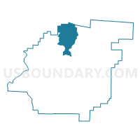
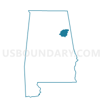
Webster's Chapel, Calhoun County, Alabama
About
Outline

Summary
| Unique Area Identifier | 521315 |
| Name | Webster's Chapel |
| County | Calhoun County |
| State | Alabama |
| Area (square miles) | 32.63 |
| Land Area (square miles) | 32.52 |
| Water Area (square miles) | 0.11 |
| % of Land Area | 99.65 |
| % of Water Area | 0.35 |
| Latitude of the Internal Point | 33.90157730 |
| Longtitude of the Internal Point | -85.85635780 |
Maps

Graphs
Select a template below for downloading or customizing gragh for Webster's Chapel, Calhoun County, Alabama


Neighbors
Neighoring Voting District (by Name) Neighboring Voting District on the Map
- Alexandria Civitan Club, Calhoun County, AL
- Asberry Baptist Church, Calhoun County, AL
- Friendship Baptist Church, Calhoun County, AL
- George Wallace Senior Citizens, Etowah County, AL
- Hokes Bluff Community Center, Etowah County, AL
- Oak Grove Baptist Voting District, Calhoun County, AL
- Weaver First United Methodist/Angel Fire Dept. Voting District, Calhoun County, AL
Top 10 Neighboring County Subdivision (by Population) Neighboring County Subdivision on the Map
- Gadsden CCD, Etowah County, AL (72,028)
- Jacksonville CCD, Calhoun County, AL (18,722)
- Alexandria-Webster Chapel CCD, Calhoun County, AL (11,730)
- Hokes Bluff CCD, Etowah County, AL (9,279)
Top 10 Neighboring Place (by Population) Neighboring Place on the Map
Top 10 Neighboring Unified School District (by Population) Neighboring Unified School District on the Map
Top 10 Neighboring State Legislative District Lower Chamber (by Population) Neighboring State Legislative District Lower Chamber on the Map
- State House District 40, AL (49,653)
- State House District 30, AL (44,979)
- State House District 28, AL (40,514)
Top 10 Neighboring State Legislative District Upper Chamber (by Population) Neighboring State Legislative District Upper Chamber on the Map
Top 10 Neighboring 111th Congressional District (by Population) Neighboring 111th Congressional District on the Map
Top 10 Neighboring Census Tract (by Population) Neighboring Census Tract on the Map
- Census Tract 25.01, Calhoun County, AL (7,069)
- Census Tract 105.02, Etowah County, AL (4,988)
- Census Tract 25.02, Calhoun County, AL (4,661)
- Census Tract 24, Calhoun County, AL (4,518)
- Census Tract 106.02, Etowah County, AL (3,984)